Saturday, May 31, 2008

From Delmarva to the Atlantic Ocean

From Delmarva to the Atlantic Ocean, a lot has been going on in the world of weather.

Let's first start the with the 2008 Atlantic Hurricane Season. The offical start of the season is June 1st, however Tropical Storm Arthur couldn't wait and came a day early.

What's interesting about Tropical Storm Arthur, is not only was he the first tropical storm for the Atlantic Hurricane Season, this same system was also previously know as "Alma." That's right, this storm was also the first tropical system for the Eastern Pacific Hurricane Season. Alma made landfall, weakening and crossing Honduras, this system then reformed in the Atlantic, becoming Tropical Storm Arthur. Here is the five day forecast for this storm:


On Delmarva, the day started off with tornado watches around 10:30 a.m. We saw everything from tornado watches to warnings, to severe thunderstorm warnings and flash flood warnings.


So far, no tornado reports have come in for Delmarva, but not to far west, a tornado report from this same system came in for Garrett County, Maryland.

The tornado was an EF0. It had a path length of one and one half miles and a width of 80 yards. It had maximum winds of 80 mph. Two houses suffered damage, along with downed trees. One person was injured from flying glass during this tornado.

The image below shows the storm a little bit after 11 p.m.


Back to Delmarva, so far there have only been wind and hail reports. Nickel sized hail was reported in Caroline County (Denton,) Downed trees were reported in Accomack (Atlanta) and Dorchester (Hurlock) counties and wires were down in Sussex County (Milton.)

Another interesting thing about this day: An F0 hit Accomack County back in 1962.

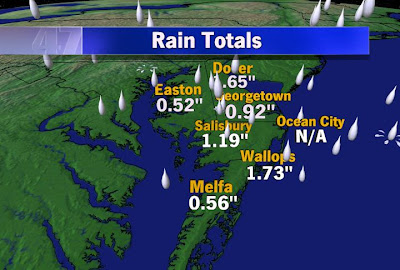
Finally, your rainfall totals from this system as of 11 p.m. Saturday.
Wallops Island: 1.54"
Salisbury: 1.12"
Georgetown: 1.11"
Melfa: 0.56"
Dover: 0.46"

Friday, May 30, 2008

Above Average Hurricane Season Expected

I'll keep it on the hurricane topic since we are almost at the start of the season. Incase you forgot, the Atlantic Hurricane Season runs from June 1-November 30th, with the peak of the season in early September. I'll recap the predictions again for this year. NOAA is predicting another active hurricane season. On average this is what you can expect:
Named Storms: 11
Hurricanes: 6
Major Hurricanes (cat 3+):2

2008 Prediction
Named Storms: 12-16
Hurricanes: 6-9
Major Hurricanes (cat 3+): 2-5

The factors leading to a above average season are the multi-decadal signal of climate conditions that have lead to active seasons since 1995. Also, favorable winds, low wind shear, and high pressure in the upper-atmosphere over favorable tropical development areas contribute to the above average forecast.

This first name of the 2008 season is Arthur.

Hurricane Season is Approaching

The countdown stands at two. Two days until the 2008 Atlantic Hurricane Season kicks off. So here are answers to some common hurricane questions...

1. What's the difference between a hurricane and typhoon?
Hurricanes, typhones, cyclones. They're all the same thing. It just depends where they form. Hurricanes form in the North Atlantic Ocean and the Northeast Pacific Ocean. Typhoons form in the Northwest Pacific Ocean. Tropical cyclones form in the Indian Ocean.

2. How do these storms form?
You need warm water, light winds, and high humidity. Hurricanes get their energy from pulling in warm, moist air at the base of the storm. The storm then extracts the heat and water and pushes the excess air out at the top of the storm. Here's a crazy fact I found...an average hurricane releases heat equivalent to the total electrical energy consumed annually in the US.

3. What about historic hurricanes that have impacted Delmarva?
First Hurricane Donna in 1960. It was the fifth strongest hurricane to hit the US. Donna is the only hurricane on record to produce hurricane-force winds in every state along the eastern seaboard from Florida to Maine.
Courtesy NHC

Second Hurricane Camille in 1969. It was the second most intense hurricane on record to hit the United States. Even though it was only a tropical depression when it passed through Virginia, it dumped 12 to 31" of rain in just a few hours.
Courtesy NHC

Finally, Hurricane Floyd in 1999. Torential rains hit Delmarva. There were reports of over 12" of rain in less than 12 hours.Courtesy NHC

4. How do they come up with the storm names?
The list of storm names actually repeats every 6 years. The only way that list changes is if a storm is very powerful and causes massive death and destruction. Dean, Felix, and Noel are retired names from last year.

The Eastern Pacific Hurricane Season is off to a fast start. That hurricane season started May 15th. As of the 5 AM update from the NHC, Tropical Depression Alma was inland over Honduras about 85 miles. The circulation is expected to weaken to a remnant low and reach Guatemala or Belize later today.

Thursday, May 29, 2008

What's That In the Sky?

If you weren't looking up yesterday, you probably missed it.


What is it, you ask? It's called a sun halo. Here are a few other pictures I snapped Wednesday afternoon.
Okay, so what is it? Basically it's an optical phenomenon that appears as a bright, white ring around the sun or moon. High clouds, called cirrus clouds, are made up of ice crystals. When light passes through them the light is refracted and forms a halo. Depending on the shape and orientation of the crystals, different types of halos may be observed. It's interesting to note that halos and other optical phenomenon were once used to forecast the weather before meteorology was developed.

Looking ahead...there is a brand new tropical depression in the Eastern Pacific. I'll write more about hurricanes tomorrow.

Wednesday, May 28, 2008

Near Record Low Temperatures

High pressure building into the Ohio Valley tonight will provide good radiational cooling conditions allowing temperatures to cool down. A cool air mass has settled into the mid-Atlantic but high pressure off to the West will provide clear skies and calm winds. These are two ingredients needed for radiational cooling. This is when all the daytime heating at the surface escapes back into the atmosphere. The air mass is very dry as well. Current dew points are in the 40s and may drop into the 30s overnight in many areas. This air mass along with the clear skies and calm winds will allow the typical cold spots on Delmarva to drop into the 30s. Salisbury will have a good shot at reaching or breaking the record low as well as Wallops Island.
Here are some record lows for Thursday May 29.
Georgetown: 39
Salisbury: 35
Wallops Island: 47

Deadly Twisters

It seems like every week, there's another tornado causing more destruction somewhere across the country. So far this year there have been over 1000 tornado reports, 1191 reports to be exact according to SPC. There were 48 tornado reports just on Sunday (5/25/08) alone! One of those was an extremely strong and rare EF 5 tornado that destroyed Parkersburg, Iowa. Here's an aerial shot of the damage...literally nothing is left of the town.

Source AP

Winds were estimated to be 205 mph and at one point in time, the twister was 1.2 miles wide!! The tornado was on the ground for an incredible 43 miles, but not EF 5 strength the whole time. This is only the second EF 5 tornado since the EF scale was implemented. The first killed 11 people and almost completely wiped out Greensburg, Kansas on May 4, 2007. This is the first EF 5 tornado to hit Iowa in over 30 years! The last one hit Jordan, Iowa on June 13, 1976.


Parkersburg, Iowa...Source yahoo

The storm was so powerful that it not only knocked over big trees like this one, but it ripped the bark off of trees!! According to recent reports, 350 homes were destroyed and 100 more suffered major damage. Unfortunately the death toll stands at 6, but it could have been much worse. In an ironic twist, a tornado siren was installed in Parkersburg just 10 days before the twister hit. According to reports, many have said that if it weren't for the siren, the death toll would be much higher. Clean up is expected to take months.

Tuesday, May 27, 2008

Useasonably Cool Air Approaching

As Kira mentioned, the warmth will be gone after tonight. I'm sure summer weather lovers had a tough time heading back to the office today with highs reaching the 80s again. The cold front is slated to come through overnight tonight and replace us with a much cooler air mass. I just checked the recent observations around the mid-Atlantic and Northeast and I am impressed at the temperature gradient. Currently it is 79 degrees in Norfolk, VA and 48 degrees in Binghamton, NY. The front right now looks to be in Northern MD and is closing in on Delmarva. A nice line of showers and storms has developed along the front and is pushing Southeast through Northern Delaware and the upper MD shore right now. No storms are severe at the moment but are capable of strong wind gusts and heavy downpours. I'm also impressed at the dew points right now there are in the 60s to low 70s, indicating a very moist atmosphere. When dew points are in the 70s, that is when it's very uncomfortable. It's only late May so the prolonged period of humid days will be arriving soon.

Most of the showers should end by morning as the front moves offshore but there still may be a shower over the Southern viewing area. At this point, I do expect clouds lingering in the AM for many areas but with increasing sunshine in the afternoon. One fly in the ointment would be if the cold front slows down or even stalls overnight. This happens usually in the Summer months, especially over the Carolinas but can occur over Delmarva. If this happens expect a prolonged period of clouds with a better chance of showers over the Southern viewing areas. Highs on Wednesday will be well below average in the upper 60s. But if you want 80s, don't worry they will be back for the weekend.

Goodbye Warmth

Over the past few days, we've had some of the best weather anywhere in the country. Unfortunately, that is about to change. Some light showers dotted Delaware early this morning, but another, more potent, batch of showers and thunderstorms will appear later today. Despite some clouds, temperatures will still be warm today with highs reaching the mid 80s inland. Unlike the past few days, the dewpoint (representative of how much moisture is in the air) will also be higher today, reaching the mid 60s...making it feel more uncomfortable and muggy outside. The combination of daytime heating and higher dewpoints will help trigger some convection ahead of a cold front that will pass through late tonight into Wednesday morning. That's why the Storm Prediction Center (SPC) has placed us in a slight risk for strong storms, including damaging winds, hail, and moderate to heavy rain.


Behind the cold front, much cooler (actually unseasonably cool) weather will filter in for Wednesday. While a few showers and clouds may linger into Wednesday morning, sunshine will take control by late morning. Expect highs only in the mid to upper 60s. Temperatures rebound into the 70s as we finish out the work week.

Monday, May 26, 2008

Past Memorial Days

Delmarva saw a beautiful Memorial Day weekend with sunny skies and highs in the upper 70s to lower 80s. The official high in Salisbury, Md. was 81 degrees. Looking back on past Memorial Days, I feel like I remember a lot of wet weekends, so I was curious to see when Salisbury last saw a wet Memorial Day. Surprisingly you have to go all the way back to 2004 for rain, and last Memorial Day was much warmer! Here is a look at the weather for the past five Memorial Days.

Memorial Day 2007: Sunny/High: 89 degrees
Memorial Day 2006: Haze and Fog/High: 86 degrees
Memorial Day 2005: Haze and Fog/High: 79 degrees
Memorial Day 2004: Rain/High: 76 degrees
Memorial Day 2003: Rain/High: 64 degrees

Depending on the type of weather you prefer, maybe better beach weather last Memorial Day, but at least we weren't wet and in the 60s like we were in 2003!

La Niña Ending

For almost a year, La Niña has been in action in the central Pacific Ocean. La Niña is the cooling of ocean surface temperatures in the central and east-central equatorial Pacific Ocean that influences U.S. weather patterns. It developed July through September 2007 and became strong throughout the winter months, from December 2007 through February 2008. Throughout the winter, La Niña was associated with very heavy precipitation in the Ohio Valley and in the northern Rockies, and drier-than-average conditions over parts of the southern Plains and the Southeast.

Now, scientists believe
La Niña could soon be coming to an end. According to research La Niña weakened in April and they predict that will continue and it will transition to a neutral phase during June or July. Typically, La Niña does not have strong impacts for the US within the spring and early summer, however, La Niña can influence the hurricane season in late summer and fall.

Story courtesy of NOAA’s Climate Prediction Center

Sunday, May 25, 2008

The Naming of Hurricanes: Part Four

We’ve discussed a few theories on when the naming of storms began, but the “informal practice of naming tropical storms became institutionalized in 1950, when the U.S. Weather Bureau identified tropical cyclones of the North Atlantic Ocean using a phonetic alphabet.” This system was used until 1953, when the names switched from the phonetic alphabet to women’s names. If you’ve never noticed before, the list actually stops short of q, u, x, y and z, because there are not a lot of names that begin with these letters.

“Tropical cyclones near Hawaii and the Pacific were given women’s names starting in 1959 and, beginning in 1960, tropical cyclones in the remainder of the Northeast Pacific basin were also nicknamed with women’s names.”

Why only women’s names?

Eventually pressure was placed on the World Meteorological Organization to include men’s names and on July 10, 1979, the first Atlantic hurricane named with a male name was “Bob.”

What happens if a storm moves into another area with different names?

“In October of 1988, after Atlantic hurricane Joan savagely struck Central America, it proceeded to move into the Pacific and became Pacific tropical storm Miriam.”

Source: Freaks of the Storm by Dr. Randy Cerveny

Saturday, May 24, 2008

The Naming of Hurricanes: Part Three

Thursday we talked about the influence of Author George R. Stewart on the naming of hurricanes and Friday we talked about the influence of the news media, but what about influences even further back in time?

Here is one theory related to religion:
“As Christianity took hold in the West Indies, memorable Caribbean hurricanes were often labeled with the name of the saint on whose day they stuck land.”

Another theory is that Australian meteorologist Clement L. Wragge was the first to begin naming tropical storms with “human” names.

“As a forecaster in 1887, Wragge began tagging personal names on to Australian weather disturbances from a wide variety of historical biblical, political, and even “alluring” names.“ The names of Xerxes and Hannibal are two examples he used. He also named “nasty storms” with the names of politicians.

“Modern hurricane researcher Chris Landsea noted that, by using such a personal naming system, Wragge could publicly describe a politician as “causing great distress” or “wandering aimlessly about the Pacific.””

Those are just a few more theories on how the naming of hurricanes began. Tomorrow I will have a look at when the names corresponding to the alphabet took effect.

Source: Freaks of the Storm by Dr. Randy Cerveny

Friday, May 23, 2008

The Naming of Hurricanes: Part Two

Yesterday we talked about Author George R. Stewart possibly influencing the naming of tropical storms through his book Storm. Another theory involves the media!

“Canadian meteorologist and weather historian David Phillips suggested that the first Atlantic tropical storm of 1949 was nicknamed by the news media “Hurricane Harry” after president Harry Truman.” A little humor about this theory comes into play when a “more violent” storm was named “Hurricane Bess” by the media after President Truman’s wife.

Check back for even more theories!

Source: Freaks of the Storm by Dr. Randy Cerveny

Thursday, May 22, 2008

The Naming of Hurricanes: Part One

Hurricanes have been named as far back as the early colonial days. One example would be the “Great Hurricane of 1780.” But when did hurricanes receive their male and female names; the names we know today, such as “Hurricane Andrew?” There are actually several theories on how this naming process came about. Here is one of several theories: Author George R. Stewart may have influenced the naming of hurricanes.

“In 1941, Stewart wrote the best-selling novel Storm in which a junior meteorologist at the San Francisco office of the U.S. Weather Bureau justifies “the sentimental vagary” of naming any long-lasting storm by telling himself that each storm is “really an individual.”

It is believed during World War II, after reading Stewart’s book, navy meteorologists named tropical storms in the Pacific Ocean after their girlfriends and wives.

Check back for more theories!

Source: Freaks of the Storm by Dr. Randy Cerveny

Hurricane Season Prediction

The NWS just released their 2008 Atlantic hurricane season prediction. With a 90% chance, scientists believe this year's season will be near normal or even above normal. The outlook indicates a 60-70 percent chance of 12 to 16 named storms, including 6 to 9 hurricanes, and 2 to 5 major hurricanes (category 3, 4 or 5). An average season has 11 named storms, 6 hurricanes, and 2 major storms. Scientists still urge everyone to be ready. The outlook is just a guide to the overall season, but officials warn that it does not predict where any of these storm may hit.

The outlook will be updated on August 7, just prior to the peak of hurricane activity. Tropical storms acquire names when they have sustained winds of at least 39 mph. Tropical storms become hurricanes when winds reach 74 mph, and become major hurricanes when winds reach 111 mph. The first named storm will be Arthur. Here's a complete list of names for the 2008 season.

2008

Arthur
Bertha
Cristobal
Dolly
Edouard
Fay
Gustav
Hanna
Ike
Josephine
Kyle
Laura
Marco
Nana
Omar
Paloma
Rene
Sally
Teddy
Vicky
Wilfred

Wednesday, May 21, 2008

Fewer, but more intense hurricanes

A new model predicts fewer, but more intense hurricanes for the last two decades of this century. This model has "higher resolution and an improved ability to simulate past observed changes in Atlantic hurricane activity." When tested, the new model accurately simulated the past hurricane seasons from 1980 to 2006.

Many have debated the affect of "greenhouse warming" and future hurricane seasons. If "greenhouse warming" is in fact occurring, some scientists expect the rise in sea water temperatures would increase the number of hurricanes in future hurricane seasons. This new models shows the opposite. The model indicates an increase in wind shear and other components which would actually decrease the number of hurricanes per season.

Source: National Oceanic and Atmospheric Administration

But let’s talk about the current hurricane season….

Less than two weeks away from the start of the Atlantic hurricane season, but the Eastern Pacific hurricane season began on May 15th. A while ago we blogged about the 2008 Atlantic hurricane names. Here are the 2008 Eastern Pacific hurricane names:

Alma
Boris
Cristina
Douglas
Elida
Fausto
Genevieve
Hernan
Iselle
Julio
Karina
Lowell
Marie
Norbert
Odile
Polo
Rachel
Simon
Trudy
Vance
Winnie
Xavier
Yolanda
Zeke

Tuesday, May 20, 2008

Unseasonably Cool Conditions

A upper-level trough or dip in the jet stream continues to be situated over the Northeast and will continue there through the week. Underneath the trough, occurs cool air and disturbances that will impact our forecast. High temperatures will be below average in the 60s to around 70 for the rest of the week. Highs right now should be in the mid 70s.

Weak disturbances will rotate around the tough bringing some clouds and the chance for a spotty shower. There will be a chance for a shower Wednesday evening as the first disturbance moves through. Another disturbance will bring some clouds around for Thursday again with another shower possible.

The trough will begin to lift out during the holiday weekend. Highs will climb back to average on Sunday and go above average for Memorial Day and Tuesday.

Monday, May 19, 2008

Friday's Thunderstorm

The sky turned black and shortly later the rain started...

If you looked outside last Friday late afternoon, you inevitably saw the thunderstorm approaching. While it only last a short time, there were some big rain totals reported (check below for actual amounts). I was on my way to the store when the rain began. Here are some pictures I took on my way...

Route 13 South. The right lane driving northbound was completely inundated with water, forcing cars into a single lane. Some brave souls drove through it, but when you see a huge puddle like that on the road, the safest thing is NOT to drive through it. Your car could get easily stuck...


Right before the Sage Diner sign, there is a road that is completely covered with water. I was standing next to it and I couldn't even tell if it was a road or a parking lot!

What's amazing is that as quickly as the rain came, the rain left. The thunderstorm lasted less than 20 minutes and most of the water was able to drain from the road in less than 20 minutes after the rain stopped. Talk about too much rain at one time!

Sunday, May 18, 2008

Dry start to the workweek, but more rain on the way

The weather started off great for Sunday. Highs even made it around average, with a high of 74 in Salisbury. Temperatures were a little cooler in Dover with a high of 69, but Melfa warmed all the way up to 81 degrees!

Clouds eventually moved in, but rain totals were not very impressive. Georgetown only saw a trace of rain as of 9 p.m., 0.04" fell in Salisbury, but Dover saw 0.25" of rain with the line of storms pushing through the north of Delmarva. Below is the radar image. This line of storms crossed around 6:30 p.m. and brought impressive rainfall to Delmarva in a short period of time.


This week the weather will be a little instable with more chances of rain as early as late Monday night. Monday will begin mostly sunny, so it won't be another wet start to the workweek. I think the best chance will be during the day on Tuesday for some showers and storms. Chances for rain remain overnight Tuesday through Wednesday night. The good news... it looks like the upcoming weekend will be dry! The bad news... temperatures will be below average for much of the week.

Saturday, May 17, 2008

Rain yesterday, sun today, more rain tomorrow...

What a great start to the weekend! The sun was out and the temperatures were around average. Yesterday wasn't as nice, we saw a few light showers early in the day, followed by some heavy rain in the evening. The rain totals from yesterday were impressive for some areas, especially for how quickly some of the accumulation occurred. Here are those rain totals:

Salisbury: 1.15"
Wallops Island: 0.87"
Melfa: 0.61"
Georgetown: 0.54"
Easton: 0.27"
Dover: 0.19"

Sunday will start off dry with a few breaks in the clouds possible. The clouds will increase throughout the morning and rain will move onto Delmarva from the northwest. Right now models are showing rain totals right around 0.25".

Friday, May 16, 2008

Inland Flooding

Below is a radar sequence from the storms we had pop up Friday evening associated with the cold front. From the times and locations of the storm cells, you can see how quickly this system moved across the peninsula. Within minutes of the rain arriving in Sailsbury, street flooding was occuring on Salisbury Boulevald, Beaglin Park Drive and College Avenune. We saw around half an inch of rain in only minutes! So far, no other flooding reports have come in. When I called Worchester and Somerset counties, they had no reports of flooding. The good thing about this system is that it ended as quickly as it arrived, so it didn't take long for the flooding to subside.

Radar image at 4:34 p.m


Radar image at 5:09 p.m.


Radar image at 5:23 p.m.

Radar Image at 5:44 p.m.


Recycling = New Shirt

Here's this morning's Weather Matter's segment...

I found a great product that I want to share, but first here are a few facts.

1. Did you know that approximately 700 million plastic bottles end up in landfills every year?
2. Did you know that each 1.5 liter bottle recycled saves enough energy to power a 60-watt light bulb for 6 hours.
Both really good reasons to recycle.
3. Finally, did you know that recycling a bottle can add clothing to your closet?

Recently, Coca-Cola started a campaign called 'Drink 2 Wear'. As part of it, the company unveiled t-shirts made from plastic bottles and cotton.
This is the tag found inside every shirt. It shows the process from drinking to recycling to the creation of a new shirt. This particular shirt has 3 recycled coke bottles in it!

Walmart is sells these shirts. According to their website, if every customer, that's 200 million people, purchased just one recycled t-shirt, we could keep 21,000 tons of plastic waste out of landfills - enough to cover 9 football fields.

Thursday, May 15, 2008

Drought Update

Delmarva has seen a lot of rain over the past few weeks. Viewers have been calling in asking if we are still in a drought and how below average we are on rainfall. The images below are from the U.S. Drought Monitor for Delaware, Maryland and Virigina respectively. Yellow indicates abnormally dry, but no drought. Tan indicates a moderate drought, which you will find for portions of Virginia. The Delmarva Peninsula is no longer in a drought.


Last weekend I blogged about the month and year actual and average rainfall. Here is an update to those numbers:
Overall, Salisbury, Md., Georgetown, Del. and Wallops Island, Va. are all above average for monthly rainfall. All three locations are still under average for yearly rainfall, however Wallops Island, Va. is very close to where it should be. Salisbury Md. and Georgetown Del. are still almost two inches below average for the year.
Salisbury, Md.:
Month to date (Actual): 3.28"
Average: 1.84"
Year to date (Actual): 15.58"
Average: 17.52"
Georgetown, Del.:
Month to date (Actual): 4.10"
Average: 1.86"
Year to date (Actual): 14.14"
Average: 16.98"
Wallops Island, Va.:
Month to date (Actual): 3.62"
Average: 1.50"
Year to date (Actual): 14.33"
Average: 14.49"


More Tidal Flooding

The first paragraph of Justin's blog below can basically be repeated for today.

Large ocean swells combined with Southerly winds will keep water levels above average in the Chesapeake Bay again today. It's been four days now, but a coastal flood advisory is still in effect for Wicomico, Somerset, and Dorchester counties until Friday at 6 AM. Tides are running about 1-2 feet above average, so minor tidal flooding is possible around times of high tide. Here are a few high tide times:

Kent Island 3:03 pm (Thursday) 3:47 am (Friday)
St. Michaels 2:29 pm 3:13 am
Cambridge 1:59 pm 2:43 am
Crisfield 10:31 am, 10:58 pm 11:19 am

Unfortunately we have more rain headed our way tonight. An area of low pressure will track out of the lower MS River Valley along a cold front and pass right through Delmarva. We're still nailing down the exact details, but it does look like the rain will begin tonight and linger through Friday morning before tapering to scattered showers Friday afternoon. There is the potential for some of the rain on Friday morning to be heavy with some embedded thunderstorms. Obviously since the ground is already saturated and the water levels are elevated on the Bay, this is a situation that needs to be watched. But like Justin wrote below, it does appear that sunshine along with a change to a NW wind direction will help to improve conditions on Saturday.

Wednesday, May 14, 2008

Tidal Flooding

Large ocean swells combined with Southerly winds today kept water levels above average in the Chesapeake Bay. Coastal Flood Warnings and Advisories are issued for the Chesapeake Bay coasts through Thursday morning. Tides are running about 1-2 feet above average, so minor tidal flooding is possible around times of high tide. The area most prone to this looks to be Southern Dorchester County. But all the usual flood prone spots around the Bay have the threat for tidal flooding through early Thursday morning.

Another storm will approach Delmarva late Thursday into Friday providing another chance for some tidal flooding along the Bay. There looks to be a period of onshore flow that may keep water levels high as well as any runoff from any rainfall that occurs. It is possible the flood advisories and warnings could be either extended or re-issued sometime on Thursday. Some good news though as the storm passes by Friday night. There will be a stronger offshore wind For Saturday which will help push the water back out into the Ocean and lower water levels.

Hurricane Names Retired

Dean, Felix, and Noel have been retired from the list of hurricane names. An international committee decided to pull the names because of the death and devastation the three caused during the 2007 Atlantic Hurricane Season.

The committee issues a list of potential names for tropical cyclones every six years. But for 2013, Dean, Felix, and Noel have been replaced with Dorian, Fernand, and Nestor. Since 1953, when tropical cyclones were first named, 70 names have been retired, the first two being Carol and Hazel in 1954.

Here's some information about each storm:Hurricane Dean was a Category 5 storm as it hit the Mexican coast

1. In the warm Caribbean water, Dean reached Category 5 strength of 165 mph just before landfall on Aug. 21 near Costa Maya on the Yucatan Peninsula. It weakened over land but emerged into the Bay of Campeche, strengthening to Category 2 status just before landfall the next day south of Tuxpan, Mexico. Dean is directly responsible for 32 deaths across the Caribbean, with the largest tolls in Mexico and Haiti.


Hurricane Felix, a Category 5 storm, bears down on Central America.

2. Felix was the second hurricane of the season to make landfall as a Category 5 hurricane, a feat never seen before in records dating back to 1851. Felix rapidly intensified and became a Category 5 hurricane about 400 miles southeast of Jamaica. The storm weakened to Category 3 but re-intensified to Category 5 status just before landfall on Sept. 4 at Punta Gorda, Nicaragua. Felix was responsible for 130 deaths in Nicaragua and Honduras, causing major damage in northeastern Nicaragua and inland flooding over portions of Central America.


Infrared satellite image of Hurricane Noel on November 1, 2007

3. Noel was a late season storm that slowly-moved over the Dominican Republic, Haiti, eastern Cuba and the lower Bahamas from Oct. 25 to Oct. 31. The storm became a Category 1 hurricane on Nov. 1 in the northwestern Bahamas. As it accelerated northeast over the western Atlantic waters near Nantucket Island, Mass., it was no longer classified as a tropical system but packed 75 mph winds as it came ashore near Yarmouth, Nova Scotia. Noel was responsible for at least 160 deaths across the Caribbean and Bahamas. The system produced hurricane force winds over portions of the northeast U.S. and Canada, producing widespread power outages. It also produced significant coastal flooding and wave action that washed out coastal roads in portions of Nova Scotia.

Pictures and story courtesy NOAA

Tuesday, May 13, 2008

More Storm Reports

Here are more storm reports according to the NWS (Mt. Holly) from yesterday:

- Bowers, DE
COASTAL FLOODING AND EVACUATIONS FROM WOODLAND BEACH
SOUTH TO BOWERS BEACH

- Rehoboth Beach, DE
NUMEROUS TREES DOWN THROUGHOUT COUNTY

- Millsboro, DE
LONG NECK ROAD NEAR WHITE HOUSE BEACH IS FLOODED

- Long Neck, DE
REHOBOTH SHORES IN LONGNECK IS FLOODED

- Dewey Beach, DE
ROUTE 1 ONE MILE SOUTH OF DEWEY BEACH HAS WATER ACROSS
ROADWAY

- Long Neck, DE
OAK ORCHARD AREA-WATER ON ROADWAY

- Bethany Beach, DE
ROUTE 1 SOUTH BOUND, SOUTH SIDE OF INDIAN RIVER INLET
BRIDGE FLOODED

- Slaughter Beach, DE
SOME SUBDIVISIONS ARE BEING EVACUATED IN SLAUGHTER BEACH

- Milton, DE
SHORE DR IN PRIME HOOK BEACH COVERED WITH TWO FEET OF
WATER

Thankfully, sunshine along with drier weather has returned today. The dry weather will stick around for a few days before another system approaches late Thursday into Friday. Unfortunately, the weekend is looking rather unsettled with a big trough in the Eastern US keeping the chance for showers in the forecast.

Monday, May 12, 2008

Delmarva Flood Event

Strong winds in combination with high tides brought a lot of coastal flooding to Delmarva. Areas witnessed power outages, trees down blocking roads and impassible, flooded roads.

Weather Watcher Hunter Outten of Frankford, Del. had trees down blocking roads and structrual damage to his home. Here are a few pictures he sent in to us:


We also received additional reports from our Weather Watchers:

Carol Loy in Oriole, Md. reported branches down, luckily no full trees. She said she thought the water was going to get a lot higher than it did, so Carol was very happy that it didn't.

Tom Mullikin in Bethany Beach, Del. went for a drive and reported a lot of roads under water. He said there was a powerline down on Ocean Drive. Tom also said from his house the waves looked scaringly high.

Ted Parker in Millsboro, Del. (between Millsboro and Rehoboth Beach to be exact) said he had water right up to his house, but no damage. He said the water was right up to a lot of the houses near him, but didn't think there was too much damage. Ted said there were also trees down.

Hunter Outten in Frankford, Del. reported tree damage and structure damage to his house. He said he had sustained winds Sunday night of 43 mph with wind gusts over 60 mph.

Tom Loockerman in Bridgeville, Del. said he had a lot of tree limbs down around his house.

Betty Miles in George Island Landing, Md. said she had a lot of water. She said the roads down by the Bay were also covered in water. She also had a lot of down tree limbs on her driveway. Betty said it looked like her trees went through a blender! She also said the governement put out high water signs.

Paul Yannucci in Milton, Del. said there were lots roads under water and closed.

Chucky Plummer in Lewes, Del. said there were a lot of tree branches down and uprooted trees blocking the roads. He also reported a lot of roads closed towards the beach (Savannah Road was one he mentioned.) Chucky said he couldn't pass on the Lewes Bridge because it was shut down, when he tried to go to the sotre. Other than the trees and flooded roads, Chucky said the rain was extremely heavy overnight and today and the winds were very strong.

Kenny Wheatly in Cambridge, Md. said he had one and a half inches of rain piled up in his back yard and tree limbs on the road. He also reported that the lower half of the county was flooded.


Here are you rain totals for the entire event as of 10 p.m. Monday night:

Georgetown: 2.91"
Frankford, Weather Watcher Hunter Outten: 2.60"
Bridgeville, Weather Watcher Tom Loockerman: 2.40"
Milsboro, Weather Watcher Ted Parker: 2.40"
Milton, Weather Watcher Paul Yannucci: 2.25"
Fenwick Island, Weather Watcher John Barthel: 2.00"
Salisbury: 1.86"
Dover: 1.81"
Wallops Island: 1.67"
Cambridge, Weather Watcher Kenny Wheatly: 1.50"
Oriole, Weather Watcher Carol Loy: 1.50"
Lewes, Weather Watcher Chucky Plummer: 1.50"
Sharptown, Weather Watcher George Tarpley: Over 1.00"
Easton: 0.98"

Sunday, May 11, 2008

A wet end to Mother's Day

It was a dry start to Mother's Day... a great treat to all of the mom's hoping for great weather... but then the winds and rain really picked up!! We have had all sorts of wind and flood watches, warnings and advisories issued. In fact, we received a report, confirmed by fire officials, that the roof of the Grand Stand in Ocean Downs blew off.

If you read my previous blog, then you know that Delmarva is still under average on its rainfall for the year (although over for the month in some areas.) That means all of this rain will help and be great for the farmers.

Here are your rain totals for Sunday, as of 11 p.m.

Wallops Island: 1.37"
Salisbury: 1.19"
Melfa: 0.23"
Dover: 0.15"
Georgetown: 0.12"

Saturday, May 10, 2008

Still below average on rain

One of our Weather Watchers, Paul from Milton, called in tonight to ask about the drought and how low we still were with our rain totals. Even with all of the rain we saw on Friday, we are still below average! Here are the numbers:

Salisbury
Month to Date: 1.37"
Average Month to Date: 1.19"

Year to Date: 13.67"
Average Year to Date: 16.87"

Salisbury is up for the month average, but 3.2" under for the year.

Georgetown
Month to Date: 1.05"
Average Month to Date: 1.21"

Year to Date: 11.09"
Average Year to Date: 16.33"

Georgetown is 0.16" under for the month average, and 5.24" under for the year.

Wallops Island
Month to Date: 1.95"
Average Month to Date: 1.00"

Year to Date: 12.66"
Average Year to Date: 13.66"

Wallops Island is 0.95" up for the month, but 1" under for the year.


Friday, May 9, 2008

Friday Rain Totals

Areas of Delmarva saw a good amount of rain today. While the rain was probably unwanted to some people hoping for a sunny day, I'm sure the farmers were happy!! Hopefully you don't mind the rain, because there is more to come...

Cyclone Nargis vs Hurricane Katrina

Now more on Cyclone Nargis that slammed into Myanmar's coast.

Check out this picture...

Here's a satellite image of Cyclone Nargis taken as it approaches the coast on Thursday, May 1. At this point, it was a weak Category 3 storm with maximum sustained winds at 115 mph. The storm's damage covers about 11,600 square miles of land. What's remarkable is that even though that's only 5% of the country, nearly 57 million people live there.

But in an attempt to further understand the destruction that took place, let's compare Nargis to a historic Atlantic hurricane. Hurricane Katrina is one of the most devastating natural disasters in U-S history. It was the third strongest hurricane to make landfall in the U-S. You may be surprised to learn the similarities between Cyclone Nargis and Hurricane Katrina.

* They both hit low lying areas, prone to flooding.

* Both were Category 3 storms on the Saffir Simpson scale, packing 120 mph winds.

* Imagine a wall of water 24-28 feet high...that's the highest storm surge of Katrina.
Nargis had a 12 foot storm surge.

* Both dropped tremendous amounts of rain.
Slidell, Louisiana picked up the most, 15" with Katrina.
Parts of Southern Myanmar picked up 23.6" of rain!

* Over 1800 people died directly or indirectly because of Katrina.
And 1.2 million were told to evacuate.
The death toll is still going up in Myanmar, but some think it will rise to 100,000.
That would make Cyclone Nargis the deadliest cyclone to hit Asia in 17 years, when 143,000 people died from a cyclone that struck Bangladesh.

* Katrina's price tag reached $81 billion, making the costliest natural disaster ever!
There is no price tag for the devastation in Myanmar.

Unfortunately, the cyclone season in the North Indian Ocean just started. It runs from April through December. But despite the long season, the region on average has just over 5 named storms per year with 2 becoming full tropical cyclones.

Thursday, May 8, 2008

What's the radar picking up?

I was looking around on the Storm Prediction Center website and I came across this radar image from March 19, 2006.
You can see the hook echo, gust front and supercell, but check out the other spots on the radar. I wonder how many meteorologists mistaked these spots for rain, when it was actually a group of bats!!

Other than bats, a lot of things can show up on radar. Scienctist have been studying the migration of the Monarch Butterfly, what better to track their paths than radar!

Storminess On Its Way

The first round of showers arrived today. But that's only a sign of things to come...

Here's a GFS forecast map for 8 AM this morning. There's a cold front stalled to our north and an area of low pressure at the tail end of it. NOTICE THE PLACEMENT OF THE LOW PRESSURE. The scattered showers will continue this afternoon. But as we head into tonight that low will approach sparking heavier rain and possibly a thunderstorm. Northern Delmarva could pick up over 1.5" of rain out of this system if the axis of heavy precipitation passes through that region (what the models are currently saying.) But there's more...


This next forecast map is Sunday morning at 2 am.
Notice, the placement of the next low?? Look familiar? The next storm will also move out of the Plains and into the Ohio River Valley bringing showers to Delmarva late Sunday into Monday. But there's more...

This is a forecast map for next Wednesday night.
Granted this is still far out, but I thought it was interesting to again, notice the placement of the low pressure system. All of the systems have been near the Mississippi River, around the Missouri/Arkansas border. Will that be our next rain maker late next week?? We'll just have to wait to see...

Wednesday, May 7, 2008

Cyclone Updates

In my last blog on the Myanmar Cyclone, I mentioned that 350 people were feared dead. Here are some update facts on this situation from CNN.

-U.S. figures estimate more than 100,000 people may be dead
-Myanmar figures estimate that 22,000 people may be dead
-The Cyclone made landfall with wind gusts up to 150 mph and a storm surge of about 12 ft.
-95 percent of buildings in the delta region were destroyed
-According the the Myanmar Government, 41,000 people are missing from the delta region
-One million people are homeless
-2,000 square miles of the delta are still underwater.

Warm Today, Unsettled Tomorrow

Like Justin mentioned below, unseasonably warm weather is headed our way today. But enjoy it while it lasts because it will turn a little unsettled beginning on Thursday. A cold front will head our way on Thursday sparking a chance for some scattered showers Thursday afternoon into the night. While these showers look to be scattered in nature, that won't be the case on Friday. The front will stall around the area and then an area of low pressure will form on the front bringing some good rain (possibly thunderstorms/heavy rain??) for Friday. Despite everyone's love of sunshine, the rain is a welcome site seeing that Salisbury is now 4.08" below normal for the year. We've only picked up 12.31" of rain so far this year...that's 2.14" less than last year!

Friday's system exits the coast and we should see some sunshine on Saturday and maybe early Sunday before the next system approaches. Another low pressure system will head our way bringing a chance for showers late Sunday (Mother's Day) into Monday. Hopefully we can pick up some beneficial rain out of these systems...

Tuesday, May 6, 2008

80s Return

So far this year there have been 5 days at least 80 degrees in Salisbury, which is not uncommon. However it is not until early June where the average high is 80 degrees. Tomorrow looks to be our 5th day of 80 degree temperatures. High pressure drifts offshore during the day and the flow around high pressure is clockwise. So if you are on the backside of a high pressure system, you will have Southerly winds. These Southerly winds will combine with strong May sunshine allowing temperatures to reach 80 degrees or higher away from the water.

The 80 degree temperatures will not be long lived as a frontal boundary approaches on Thursday and Friday bringing clouds and the chance for showers, especially on Friday as an area of low pressure crosses the mid-Atlantic. Temperatures fall to near average on Friday into the weekend.

Monday, May 5, 2008

Hurricane Survival Show

Incase you forgot, The Atlantic Hurricane Season begins on June 1st. WMDT and Delmarva's CW3 will be airing "The 2008 National Hurricane Survival Test" The show is hosted by Dr. Bob Sheets, former director of the National Hurricane Center. The show is 1/2 hour and focuses on questions about safety and preparedness, storm stories and safety tips.

Here are the show times:
Thu 6/12 on CW3 at 11:30am
Sat 6/14 on WMDT at 5:30pm
Sun 7/6 on CW3 at 7:30am
Sun. 7/20 on WMDT at 4:30pm
Fri 8/15 on CW3 at 11:30am
Sun 8/17 WMDT at 3:00pm

Sunny Monday, Finally

Finally the spell has been broken. Well at least it's felt like a spell. It has been six weeks since we have started the week on a dry and sunny note. Take a look:

April 28 - 0.98"
April 21 - 1.76"
April 14 - 0.01"
April 7 - 0.01"
March 31 - 0.03"
March 24 - Partly sunny skies, no rain!

High pressure will provide lots of sun today and on Tuesday before it moves off the coast on Wednesday. Highs will be near 70 today, in the mid 70s tomorrow and near 80 on Wednesday! While there is still a lot of uncertainty with the next storm system, it looks to approach Thursday into Friday bringing with it a chance for showers. Obviously as we get closer to the date, the models will come more in line with one another and converge at a solution. As of now, it also looks like the system will exit the coast and the weather will clear up for Mother's Day weekend. Hopefully the spell doesn't reverse itself (and turn showery at the end of the upcoming weeks...)

Sunday, May 4, 2008

Myanmar Cyclone

While our Atlantic Hurricane season is only a little under a month away, across the country people are seeing tropical weather of their own. The image below was taken from the Associated Press. It is a satellite image of Cyclone Nargis as it made landfall on the capital of Yangon over the weekend.

The images above, also from the Associated Press, show the aftermath of the cyclone. According to the Associated Press, the storm made landfall with winds up to 150 mph. They fear 350 people may be dead; entire villages were destroyed.

According to the Joint Typhoon Warning Center, the cyclone reached sustain winds of 132 mph before making landfall. To compare the strength of this storm to well-know and recent hurricanes in the United States, this is equivalent to a Category 4 hurricane (winds 131-155 mph.) Hurricane Charley, which made landfall in 2004 just north of Captiva Island, Fla., continuing on to Punta Gorda, just south of Ft. Meyers, Fla., was a Cat 4 storm. To compare the storm to a Cat 5 (winds greater than 155 mph,) this storm would have been weaker than Hurricane Andrew of 1992, or the well-know Hurricane Katrina. *Please note I am comparing the storms before they made landfall.*

Saturday, May 3, 2008

More updates to Midwest severe weather

Just another quick update to the previous blogs, the storm reports from Friday are now up to 55 reported tornadoes. You can certainly tell we have entered severe weather season!

Friday, May 2, 2008

Seven killed in Arkansas from severe weather

An update to the previous blog:

Since this morning, there have been even more tornado reports. According to the Associated Press, at least seven people were killed and 12 injuried today in Arkansas during severe weather. The National Weather Service is still trying to confirm if this was a tornado or straight line wind. This same "tornado" may have destroyed, "28 homes, a church, three businesses and six chicken houses."

Here are some pictures of the event from Little Rock-KTHV:


Another picture from the Associated Press:
As you can see on the image below, a total of 27 tornadoes have been reported to the National Weather Service today.


Here We Go Again...

More severe weather is breaking out in the nation's midsection. 19 tornadoes were reported yesterday and already another one this morning. May is considered the peak of tornado season, so expect this pattern to continue. But in the wake of VA's tornado outbreak and all of the interest in tornadoes, I decided to dedicate a Weather Matters segment to tornadoes.


We've all seen the pictures. We all know just how powerful Mother Nature can be. Did you know that each year there are over 1,000 tornadoes that hit the U-S. Since we're entering the peak of the season, here are a few questions answered.

1. First, how does a tornado form?

Tornadoes form when warm moist air is trapped underneath a layer of cold, dry air. This is very unstable. Eventually the warm bottom layer gets pushed up. As it rises, it cools, forming clouds and thunderstorms. If the conditions are right, the rising air will spin around a central funnel - at speeds sometimes exceeding 250 mph. A tornado technically is born when this funnel cloud touches down on the ground.

2. Why are they so unpredictable?
Scientists do not fully understand tornadoes.


Scientists at the Storm Prediction Center, SPC, in Norman Oklahoma predict where tornado-generating storms are mostly likely to form each day. But it's extremely difficult to tell which thunderstorm will spawn a tornado.

3. How big are tornadoes and long can one last?
Damage paths can be larger than one mile wide and 50 miles long. Tornadoes can last from several seconds to more than an hour. Most tornadoes last less than 10 minutes. The Suffolk tornado lasted 15 minutes.


4. When / where was the largest/deadliest tornado on record?


The biggest recorded tornado was nearly two and a half miles wide.
It occurred near Hallam, Nebraska, on May 22, 2004.
But remember that size does not necessarily imply strength.

The most deadly single tornado in history was the Tri-state twister of March 18, 1925.


It moved across Missouri, Illinois and Indiana at speeds greater than 60 mph, this F5 tornado covered 219 miles and killed 695 people.

5. Where should you go if you hear there's a tornado warning for your area?
First, stay away from all windows! Your best choice is a basement or storm shelter. Get under something sturdy to shelter you from falling debris. If you don't have either, go to an interior room without windows, like a bathroom or closet. If you're on the road leave your car and seek shelter in a nearby building. If you're not near a building, get down in a sheltered low spot and cover your head with your arms.

Information and pictures courtesy of:
www.harkphoto.com
www.armageddononline.org
http://www.spc.noaa.gov/faq/tornado/
http://www.nssl.noaa.gov/faq/faq_safety.php
http://www.nssl.noaa.gov/edu/safety/tornadoguide.html