After 4 days of true summer heat, the heat wave looks to be over. Here's a look at Salisbury's high temps over the past four days:
Thursday (6/26) - 92°
Friday (6/26) - 91°
Saturday (6/26) - 92°
Sunday (6/26) - 91°
Today looks to remain warm but shy of that 90° mark. A stationary front, which used to be a cold front, will remain draped along the Eastern seaboard today. The front along with some upper level energy rotating through the area will act as trigger mechanisms to spark showers and thunderstorms across the Mid Atlantic. While isolated light rain showers are currently appearing across Delmarva, the best chance for storms will occur this afternoon/evening. The front finally exits the coast tomorrow and a much cooler and less humid airmass will filter in. There is a slight chance for an afternoon shower tomorrow, but the bulk of the area should remain dry. High pressure builds in for Wednesday and Thursday providing mostly sunny conditions. Another cold front will approach for July 4th but it looks like the best chance for showers will hold off until the weekend (if even then...). With a big Bermuda high sitting off the southeast coast, we'll see if the cold front can even make it this far south. If the cold front stalls to our north, we would remain sunny and warm. Stay tuned...
Monday, June 30, 2008
Sunday, June 29, 2008
On June 30th in History...
Still no activity on the Atlantic basin and the same situation as blogged about below for the Pacific, but in the past things were a little different for June 30th.
In 1989:
"29.52 inches of rain fell in 6 days from Tropical Storm Allison in Winnfield, Louisiana."
Also:
"Shreveport LA finishes its wettest June ever with 17.11 inches of rain during the month. The previous mark was 14.67 inches, set in 1986. Some areas received as much as 24 inches. The excessive rainfall was primarily the result of the remnants of Tropical Storm Allison."
In 1994:
"Tropical Storm Alberto moved inland near Panama City, Florida, causing virtually no damage. The storm then stalled over south Georgia. Over 20 inches of rain fell in some areas, causing extensive flooding that drove 30,000 people from their homes."
Source: http://www.theweathercompany.com/cgi-bin/wxnotebooksearch.pl
Saturday, June 28, 2008
Tropical Storms in the Pacific
While there is no activity on the Atlantic, there are two tropical storms in the Pacific basin. Here are a few images from The Weather Channel:
"B"

"C"

And a look at the Satellite Image:

"B"

"C"

And a look at the Satellite Image:

Friday, June 27, 2008
Delmarva Highs
Following up on Kira's blog this morning, no record highs, but she was right when she said it would be a close one for Wallops Island.... 91 as the high today in Wallops Island, so a degree shy of tying the old record!! Here are the rest of today's highs:
Salisbury: 91
Ocean City: 93
Dover: 93
Georgetown: 94
Melfa: 97
Wallops Island: 91
Salisbury: 91
Ocean City: 93
Dover: 93
Georgetown: 94
Melfa: 97
Wallops Island: 91
Heat Continues
While no records were broken yesterday, Wallops Island may break their record for today. Here are a list of today's record highs across the area:
Georgetown 98 - 1952
Salisbury 99 - 1952
Wallops Island 92 - 2003, 1989
Similarly to yesterday, the chance for showers and storms exists today. That's why the Storm Prediction Center has placed part of the area in a slight risk for severe storms (the area highlighted in green).

A chunk of energy will move across the Mid Atlantic today. With strong heating and lots of moisture in the atmosphere, thunderstorms are possible later this afternoon through the evening. Remember if you're outdoors and the sky darkens, head inside and take cover.
Thursday, June 26, 2008
Hot Weekend Ahead
As Kira mentioned, another old fashioned heat wave is underway, but not as hot as the heat wave earlier in the month. Classic setup with high pressure off the East Coast with Southwesterly flow pumping in the heat and humidity. High temperatures today topped off in the low to mid 90s around the shore. Not quite near the record highs on upper 90s to around 100 as no records were set today. However, the 90s will continue through Sunday.
Just as mentioned below, with the increased humidity and daytime heating, there remains be a chance of isolated storms on Friday and Saturday. A slow moving cold front is still slated to approach later Sunday and Monday providing a better chance of scattered showers and storms during this time period. I am thinking Monday looks like the best bet for any wet weather. Right now, it looks like the front will slide offshore enough by Tuesday to bring some relief from the heat and humidity. Highs will then drop into the mid 80s for mid-week with lower humidity. Stay cool!!!
Just as mentioned below, with the increased humidity and daytime heating, there remains be a chance of isolated storms on Friday and Saturday. A slow moving cold front is still slated to approach later Sunday and Monday providing a better chance of scattered showers and storms during this time period. I am thinking Monday looks like the best bet for any wet weather. Right now, it looks like the front will slide offshore enough by Tuesday to bring some relief from the heat and humidity. Highs will then drop into the mid 80s for mid-week with lower humidity. Stay cool!!!
Welcome back summer!
If you missed the heat and humidity of days past, well, you get another chance to enjoy it. The next few days will be well above average with highs reaching the mid 90s with dewpoints in the upper 60s! It could be another mini-heat wave if we have 3 or more consecutive days of 90+ temperatures. Here are list of today's records...
Georgetown 99 - 1952
Salisbury 100 - 1952
Wallops Island 93 - 2003, 1968
While it doesn't look like Salisbury or Georgetown will break their records, Wallops Island should come close.
A big Bermuda high pressure system will sit off the southeast coast pumping heat and humidity northward. The heat index, or what it feels like, will be near 100° over the next few days. In typical summertime fashion, there is a chance for scattered pop up showers/storms each day. The best chance for showers will hold off until Sunday and Monday when a cold front is expected to pass through the area. Highs should remain in the mid to upper 80s for the beginning of July.
As of yesterday, June was averaging 3.99° above normal (for the high temperature). With temperatures expected to stay in the 90s, June should end well above average. Will it continue into July?? Stay tuned...
Wednesday, June 25, 2008
Lightning Awareness Week
As Lightning Awareness Week continues, today's topic is lightning safety. Below is some important safety information for when you are outside, inside, or on the water.
Safe Buildings
"A safe building is one that is fully enclosed with a roof, walls and floor, such as a home, school, office building or a shopping center. Even inside, you should take precautions. Picnic shelters, dugouts, sheds and other partially open or small structures are NOT safe."
"Enclosed buildings are safe because of wiring and plumbing. If lightning strikes these types of buildings, or an outside telephone pole, the electrical current from the flash will typically travel through the wiring or the plumbing into the ground. This is why you should stay away from showers, sinks, hot tubs, etc., and electronic equipment such as TVs, radios, and computers."
"Lightning can damage or destroy electronics so it's important to have a proper lightning protection system connected to your electronic equipment. The American Meteorological Society has tips for protecting your electronics from lightning."
Unsafe Buildings
"Examples of buildings which are unsafe include car ports, covered but open garages, covered patio, picnic shelters, beach shacks/pavilions, golf shelters, camping tents, large outdoor tents, baseball dugouts and other small buildings such as sheds and greenhouses that do not have electricity or plumbing."
Safe Vehicle
"A safe vehicle is a hard-topped car, SUV, minivan, bus, tractor, etc. (soft-topped convertibles are not safe) . If you seek shelter in your vehicle, make sure all doors are closed and windows rolled up. Do not touch any metal surfaces."
"If you're driving when a thunderstorm starts, pull off the roadway. A lightning flash hitting the vehicle could startle you and cause temporary blindness, especially at night."
"Do not use electronic devices such as HAM radios during a thunderstorm. Lightning striking the vehicle, especially the antennas, could cause serious injury if you are talking on the radio or holding the microphone at the time of the flash. Emergency officials such as police officers, firefighters, security officers, etc., should use extreme caution using radio equipment when lightning is in the area."
"Your vehicle and its electronics may be damaged if hit by lightning. Vehicles struck by lightning are known to have flat tires the next day. This occurs because the lightning punctures tiny holes in the tires. Vehicles have caught fire after being struck by lightning; however, there is no modern day documented cases of vehicles "exploding" due to a lightning flash."
When a Safe Location is Nearby:
"Seek safe shelter when you first hear thunder, see dark threatening clouds developing overhead or lightning. Count the seconds between the time you see lightning and hear the thunder.
Stay inside until 30 minutes after you last hear thunder."
"Figure: When you hear thunder, run to the nearest large building or a fully enclosed vehicle. You are not safe anywhere outside."
"Plan Ahead! Your best source of up-to-date weather information is a NOAA Weather Radio (NWR). Portable weather radios are handy for outdoor activities. If you don't have NWR, stay up to date via internet, TV, local radio or cell phone. If you are in a group, make sure all leaders or members of the group have a lightning safety plan and are ready to use it."
"Determine how far you are from a safe enclosed building or a safe vehicle. As soon as you hear thunder, see lightning or see dark threatening clouds, get to a safe location. Then wait 30 minutes after the last rumble of thunder before you leave the safe location. If you are part of a group, particularly a large one, you will need more time to get all group members to safety. NWS recommends having professional lightning detection equipment so your group can be alerted from significant distances from the event site."
"When groups are involved, the time needed to get to safety increases. So you need to start leaving sooner. Your entire group should already be in a safe location when the approaching storm reaches within 5 miles from your location."
On the Water
"The vast majority of lightning injuries and deaths on boats occur on small boats with NO cabin. It is crucial to listen to the weather on a small aquatic vessel without a cabin. If thunderstorms are forecast, don't go out. If you are out on the water and skies are threatening, get back to land and find a safe building or vehicle."
"Boats with cabins offer a safer but not perfect environment. Safety is increased further if the boat has a properly installed lightning protection system. If you are inside the cabin, stay away from metal and all electrical components. STAY OFF THE RADIO UNLESS IT IS AN ABSOLUTE EMERGENCY!"
"What should you do if you are on a small vessel and lightning becomes a threat? If the vessel has an anchor, then you should properly anchor the boat then get as low as possible."
"Large boats with cabins, especially those with lightning protection systems properly installed or metal marine vessels are relatively safe. Remember to stay inside the cabin and away from any metal surfaces."
Source: NOAA
Tuesday, June 24, 2008
Lightning Safety Awareness Week Part Two
Keeping with the theme of Lightning Safety Awareness Week, here are some facts from www.noaa.gov about lightning.
"Each spark of lightning can reach over five miles in length, soar to temperatures of approximately 50,000 degrees Fahrenheit, and contain 100 million electrical volts. "
"At any given moment, there are 1,800 thunderstorms in progress somewhere on the earth. This amounts to 16 million storms each year! "
"Lightning has been seen in volcanic eruptions, extremely intense forest fires, surface nuclear detonations, heavy snowstorms, and in large hurricanes, however, it is most often seen in thunderstorms."
"Ice in a cloud seems to be a key element in the development of lightning. Storms that fail to produce quantities of ice may also fail to produce lightning. In a storm, the ice particles vary in size from small ice crystals to larger hailstones, but in the rising and sinking motions within the storm there are a lot of collisions between the particles. This causes a separation of electrical charges. Positively charged ice crystals rise to the top of the thunderstorm, and negatively charged ice particles and hailstones drop to the middle and lower parts of the storm. Enormous charge differences (electrical differential) develops. "
"A moving thunderstorm gathers another pool of positively charged particles along the ground that travel with the storm. As the differences in charges continue to increase, positively charged particles rise up taller objects such as trees, houses, and telephone poles. Have you ever been under a storm and had your hair stand up? Yes, the particles also can move up you! This is one of nature's warning signs that says you are in the wrong place, and you may be a lightning target!
The negatively charged area in the storm will send out a charge toward the ground called a stepped leader. It is invisible to the human eye, and moves in steps in less than a second toward the ground. When it gets close to the ground, it is attracted by all these positively charged objects, and a channel develops. You see the electrical transfer in this channel as lightning. There may be several return strokes of electricity within the established channel that you will see as flickering lightning."
"The lightning channel heats rapidly to 50,000 degrees. The rapid expansion of heated air causes the thunder. Since light travels faster than sound in the atmosphere, the sound will be heard after the lightning. If you see lightning and hear thunder at the same time, that lightning is in your neighborhood! "
"Not all lightning forms in the negatively charged area low in the thunderstorm cloud. Some lightning originates in the cirrus anvil at the top of the thunderstorm. This area carries a large positive charge. Lightning from this area is called positive lightning. This type is particularly dangerous for several reasons. It frequently strikes away from the rain core, either ahead or behind the thunderstorm. It can strike as far as 5 or 10 miles from the storm, in areas that most people do not consider to be a lightning risk area. The other problem with positive lightning is it typically has a longer duration, so fires are more easily ignited. Positive lightning usually carries a high peak electrical current, which increases the lightning risk to an individual. "
Double Rainbow

Picture courtesy of a DC viewer!!
Some powerful storms rocked the area last night with heavy rain and lots of lightning! But before they made it to the Eastern Shore, they slammed into DC. The above picture was taken from around DC after the storms passed. It's a great shot of a double rainbow. Double rainbows aren't nearly as common as a single rainbow.
Rainbows are caused by the bending of sunlight as it goes through raindrops. The light is first refracted as it enters the surface of the raindrop, then reflected off the back of the drop, and again refracted as it leaves the drop.
Rainbows appear with red on the outer part of the arch and violet on the inner section. Unfortunately, there is no pot of gold at the end of a rainbow. That's because rainbows do not actually exist at a particular location. It is an optical illusion whose position depends on the location of the sun and person viewing it. All raindrops refract and reflect the sunlight in the same way, but only the light from some raindrops reaches the observer's eye. This light is what creates the rainbow for the person. The position of a rainbow is always in the opposite direction of the Sun with respect to the observer, and the interior is always slightly brighter than the exterior.
Occasionally, a second rainbow is found. Usually these are dimmer and thicker than the primary bow. Secondary rainbows are caused by a double reflection of sunlight inside the raindrops. As a result of the second reflection, the colors of a secondary rainbow are in reverse order compared to the primary bow. Violet appears on the outside and red is visible on the inside.
Information courtesy wikipedia.com
Monday, June 23, 2008
Lightning Safety Awareness Week
June 22nd through the 28th is Lightning Safety Awareness Week.
According to NOAA, "on average, 62 people die every year from lightning strikes, with hundreds of additional injuries reported."
Here are a few safety pointers from NOAA.
Source: www.noaa.gov
According to NOAA, "on average, 62 people die every year from lightning strikes, with hundreds of additional injuries reported."
Here are a few safety pointers from NOAA.
If you are indoors:
"*Avoid contact with electrical equipment or cords. If you plan to unplug any electronic equipment, do so well before the storm arrives.
*Avoid contact with plumbing. Do not wash your hands, do not take a shower, do not wash dishes, and do not do laundry.
*Avoid contact with corded phones.
*Stay away from windows and doors, and stay off porches.
*Wait 30 minutes after you hear the last rumble of thunder before going out again."
If you are outdoors:
"*Do not seek shelter under tall or isolated trees. Lightning typically strikes the tallest object in an area.
*Avoid open areas. You don’t want to be the tallest object.
*Do not seek shelter under partially enclosed buildings.
*If you are camping, be ready to seek safe shelter in a vehicle or substantial building if a thunderstorm threatens. A tent offers no protection from lighting.
*Stay away from metal fences and poles that could conduct lightning to you.
*If you are on a boat, return to shore immediately and seek safe shelter."
Source: www.noaa.gov
Sunday, June 22, 2008
On This Day
On Thursday the landfall of Hurricane Agnes was mentioned, today in history that hurricane had an impact on our area:
"1972 - The remnants of Hurricane Agnes cause tremendous rains of 10-20 inches across Maryland, Virginia, New York and Pennsylvania. Tremendous flooding occurred in Pennsylvania. Much of Wilkes-Baare, Pennsylvania was destroyed when floodwaters breached a dike and a wall of water inundated the town. $3.5 billion in damage and 122 killed as a result of the floods."
Not about our area, but since the Midwest has been seeing a lot of tornadoes and flooding, here are more facts about this day in history related to those topics.
"1919 - 59 people were killed as an F5 tornado ripped through the town of Fergus Falls, Minnesota. 400 buildings were destroyed. A blank check was found over 60 miles away and lumber was carried 10 miles."
"1947 - 12 inches of rain fell in 42 minutes at Holt Missouri to set a new world record for intense rainfall. The record would be tied in January 24-25, 1956 in Hawaii at the Kilauea Sugar Plantation."
Source: http://www.theweathercompany.com/cgi-bin/wxnotebook.pl
Saturday, June 21, 2008
The Other Side
As a meteorologist/journalist, it is always important to look at both sides of every issue, including "Global Warming."
This blog simply presents another side to the previous blog, "Eye Into the Future."
This blog is not implying that our weather team believes Global Warming is/is not occuring, it is simplying posting direct quotes from an article found discussed on a weather forum.
All quotes and diagrams are taken directly from The Register: "Is the earth getting warmer, or cooler? A tale of two thermometers" by Steven Goddard. The article goes further into detail and can be found at this link: http://www.theregister.co.uk/2008/05/02/a_tale_of_two_thermometers/
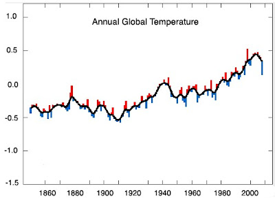
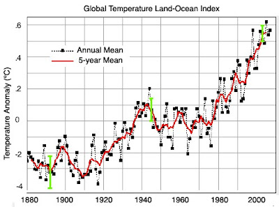
"Two authorities provide us with analysis of long-term surface temperature trends. Both agree on the global temperature trend until 1998, at which time a sharp divergence occurred. The UK Meteorological Office's Hadley Center for Climate Studies Had-Crut data shows worldwide temperatures declining since 1998. According to Hadley's data, the earth is not much warmer now than it was than it was in 1878 or 1941. By contrast, NASA data shows worldwide temperatures increasing at a record pace - and nearly a full degree warmer than 1880."
Hadley's Data from April 2008
NASA's Data from April 2008
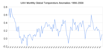
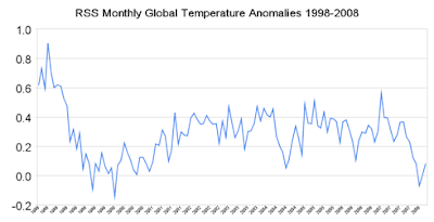
"The other two widely used global temperature data sources are from earth-orbiting satellites UAH (University of Alabama at Huntsville) and RSS (Remote Sensing Systems.)"
"Confusing? How can scientists who report measurements of the earth's temperature within one one-hundredth of a degree be unable to concur if the temperature is going up or down over a ten year period? Something appears to be inconsistent with the NASA data - but what is it?
One clue we can see is that NASA has been reworking recent temperatures upwards and older temperatures downwards - which creates a greater slope and the appearance of warming. Canadian statistician Steve McIntyre has been tracking the changes closely on his Climate Audit site, and reports that NASA is Rewriting History, Time and Time Again. The recent changes can be seen by comparing the NASA 1999 and 2007 US temperature graphs."
This blog simply presents another side to the previous blog, "Eye Into the Future."
This blog is not implying that our weather team believes Global Warming is/is not occuring, it is simplying posting direct quotes from an article found discussed on a weather forum.
All quotes and diagrams are taken directly from The Register: "Is the earth getting warmer, or cooler? A tale of two thermometers" by Steven Goddard. The article goes further into detail and can be found at this link: http://www.theregister.co.uk/2008/05/02/a_tale_of_two_thermometers/
"Two authorities provide us with analysis of long-term surface temperature trends. Both agree on the global temperature trend until 1998, at which time a sharp divergence occurred. The UK Meteorological Office's Hadley Center for Climate Studies Had-Crut data shows worldwide temperatures declining since 1998. According to Hadley's data, the earth is not much warmer now than it was than it was in 1878 or 1941. By contrast, NASA data shows worldwide temperatures increasing at a record pace - and nearly a full degree warmer than 1880."
Hadley's Data from April 2008

NASA's Data from April 2008

"The other two widely used global temperature data sources are from earth-orbiting satellites UAH (University of Alabama at Huntsville) and RSS (Remote Sensing Systems.)"


"Confusing? How can scientists who report measurements of the earth's temperature within one one-hundredth of a degree be unable to concur if the temperature is going up or down over a ten year period? Something appears to be inconsistent with the NASA data - but what is it?
One clue we can see is that NASA has been reworking recent temperatures upwards and older temperatures downwards - which creates a greater slope and the appearance of warming. Canadian statistician Steve McIntyre has been tracking the changes closely on his Climate Audit site, and reports that NASA is Rewriting History, Time and Time Again. The recent changes can be seen by comparing the NASA 1999 and 2007 US temperature graphs."
Friday, June 20, 2008
Eye Into the Future

An interesting new report was just released from the US Climate Change Science Program and the Subcommittee on Global Change Research.
It seems that extreme weather has become the norm recently. From terrible flooding in the Midwest to a record number of tornadoes and tornado deaths. What will happen to weather and climate extremes if global warming continues? That's the question answered in this recent report.
This report is the first of its kind to detail projected changes in weather and climate extremes in North America. The IPCC (Intergovernmental Panel on Climate Change) evaluated similar events but on a global basis.
The report doesn't have a very optimistic outlook for the future. According to scientific evidence, a warming world will be accompanied by changes in the intensity, duration, frequency, and geographic extent of weather and climate extremes. The report also states that droughts, heavy downpours, excessive heat, and intense hurricanes are likely to become more common as heat-trapping greenhouse gases continue to be pumped into the atmosphere.
Alarming changes, due to the warming of the Earth, have already taken place over the past few decades. The report states that continued change is projected for the future...
- Abnormally hot days and nights, along with heat waves, are very likely to become more common. Cold nights are very likely to become less common.
- Sea ice extent is expected to continue to decrease and may even disappear in the Arctic Ocean in summer in coming decades.
- Precipitation, on average, is likely to be less frequent but more intense.
- Droughts are likely to become more frequent and severe in some regions.
- Hurricanes will likely have increased precipitation and wind.
- The strongest cold-season storms in the Atlantic and Pacific are likely to produce stronger winds and higher extreme wave heights.

Hurricane Katrina's eyewall
Source: NOAA
Thursday, June 19, 2008
On this day...
A couple of random facts for today's weather blog...
First about the rather strong storms that pushed through the area last night. Lightning and thunder accompanied storms that dropped heavy rain after 11pm last night in Salisbury. According to the NWS, locally heavy downpours averaged between 1-2 inches with up to 3 inches across southern Somerset County. The NWS also reported pea to marble size hail across southern Somerset County and along the Accomack/Northampton, VA county line.
Second...On this day in history, Hurricane Agnes made landfall in the Florida panhandle.

After forming over the Yucatan Peninsula of Mexico on June 14th, Agnes became a hurricane over the southeastern Gulf of Mexico on June 18th. Agnes continued to move northward and arrived to Florida's panhandle as a Category 1 hurricane. Agnes then weakened to a depression over Georgia. It then moved over eastern North Carolina and regained tropical storm strength before moving back out into the Atlantic. A few days later, on June 22, Agnes made a final landfall near New York City just-under-hurricane-strength. The next day Agnes merged with a non-tropical low and affected the Northeast.
The major impact from Agnes was heavy rains (6-12 inches, locally 19 inches) that caused terrible flooding from the Carolinas to New York. So much fresh water was flushed into Chesapeake Bay that its seafood industry was badly damaged for several years. In an ironic twist, the flooding caused by Agnes lead to the creation of the federally financed Conrail railroad system.
Agnes caused 122 deaths in the United States...nine in Florida from severe thunderstorms while the remainder were associated with the flooding. Maryland had the highest per capita death toll of all five states declared disaster areas by President Nixon (Florida, Virginia, Maryland, Pennsylvania, and New York).
The storm was responsible for $11.6 billion (after adjusting for inflation) in damage in the United States, making it the seventh costliest storm in US history. The name Agnes was retired from the list of Atlantic storm names, making it the only category 1 hurricane to be retired at the time, and one of 5 today.
Agnes information courtesy of wikipedia.com and theweathercompany.com
First about the rather strong storms that pushed through the area last night. Lightning and thunder accompanied storms that dropped heavy rain after 11pm last night in Salisbury. According to the NWS, locally heavy downpours averaged between 1-2 inches with up to 3 inches across southern Somerset County. The NWS also reported pea to marble size hail across southern Somerset County and along the Accomack/Northampton, VA county line.
Second...On this day in history, Hurricane Agnes made landfall in the Florida panhandle.

Agnes rainfall totals; courtesy wikipedia.com
After forming over the Yucatan Peninsula of Mexico on June 14th, Agnes became a hurricane over the southeastern Gulf of Mexico on June 18th. Agnes continued to move northward and arrived to Florida's panhandle as a Category 1 hurricane. Agnes then weakened to a depression over Georgia. It then moved over eastern North Carolina and regained tropical storm strength before moving back out into the Atlantic. A few days later, on June 22, Agnes made a final landfall near New York City just-under-hurricane-strength. The next day Agnes merged with a non-tropical low and affected the Northeast.
The major impact from Agnes was heavy rains (6-12 inches, locally 19 inches) that caused terrible flooding from the Carolinas to New York. So much fresh water was flushed into Chesapeake Bay that its seafood industry was badly damaged for several years. In an ironic twist, the flooding caused by Agnes lead to the creation of the federally financed Conrail railroad system.
Agnes caused 122 deaths in the United States...nine in Florida from severe thunderstorms while the remainder were associated with the flooding. Maryland had the highest per capita death toll of all five states declared disaster areas by President Nixon (Florida, Virginia, Maryland, Pennsylvania, and New York).
The storm was responsible for $11.6 billion (after adjusting for inflation) in damage in the United States, making it the seventh costliest storm in US history. The name Agnes was retired from the list of Atlantic storm names, making it the only category 1 hurricane to be retired at the time, and one of 5 today.
Agnes information courtesy of wikipedia.com and theweathercompany.com
Wednesday, June 18, 2008
Update on Tropics

The Atlantic hurricane season started June 1st, but so far it's been quiet. We've only seen Tropical Storm Arthur which was expected to drop over 10" of rain in portions of Belize. Last year at this time, two storms had already formed, Subtropical Storm Andrea and Tropical Storm Barry.
The image above shows a tropical wave in the Atlantic that the National Hurricane Center plans to keep an eye on. As of the 8 am advisory, the storm was located about 1000 miles east of the Windward Islands and is moving westward near 20 mph. While some signs of organization are present, NHC says upper level winds are forecast to remain unfavorable for further development.
Picture courtesy of NHC
Tuesday, June 17, 2008
More Storm Reports
Here are a few other storm reports from across the Mid Atlantic region:
DOWNTOWN RICHMOND (CITY OF RICHMOND) VA - 70 MPH ESTIMATED GUST IN CHURCH HILL
MILLINGTON KENT MD - TREES AND WIRES DOWN IN MILLINGTON
NE ALEXANDRIA DISTRICT OF COLUMBIA DC - 62 MPH WIND GUST MEASURED AT WASHINGTON NATIONALS BALLPARK
WASHINGTON DISTRICT OF COLUMBIA DC - LARGE TENT DAMAGED. 10 INJURED...3 ADULTS AND 7 CHILDREN.
The drop in temperatures is also impressive. Salisbury's airport dropped from 84 degrees at 6 pm to 65 degrees at 7 pm! A cooler and more comfortable airmass will build into the area for midweek.
Monday, June 16, 2008
Monday Storm Reports
Strong to severe storms trackes across Delmarva this evening resulting in some wind damage arround Delmarva. Here are the reports as of 10PM:
2 N EXMORE ACCOMACK VA 3756 7582 POWER LINES DOWN. (AKQ)
WHALEYVILLE WORCESTER MD 3840 7530 NUMEROUS TREES DOWN (AKQ)
S DELMAR WICOMICO MD 3845 7557 TREES AND SIDING FROM AN APARTMENT BUILDING DOWN ON SOUTHSIDE OF DELMAR (AKQ)
N CAMBRIDGE DORCHESTER MD 3856 7608 LARGE TREE DOWN IN CAMBRIDGE (AKQ)
CLAYTON KENT DE 3929 7563 WIRES DOWN IN CLAYTON. (PHI)
After the storms passed, the sun came out in the West, while it was still raining in the East. This caused this nice double rainbow to develop and had great views in Delaware. Photo taken by Travis Michels

Severe Weather Threat

A significant pattern change will take place today. After last week's (and even today's) very warm temperatures with highs near 90 degrees, temperatures will cool down to the upper 70s for the middle part of the week. The transition to cooler temperatures will occur thanks in part to a cold front. Let's spell it out...
Thunderstorms are already popping up in West Virginia, and northern Kentucky. That activity will become more widespread this afternoon/evening during the heating of the day. The right ingredients seem to be coming together for thunderstorms to develop this afternoon. That's why SPC has placed all of Delmarva in a slight risk (green on picture) for severe storms and the northern part of the peninsula in a moderate risk (red on picture) for storms. Ahead of the front, lots of warm moist air will be pumped in from the south allowing the atmosphere to become unstable. That plus strong winds aloft will favor thunderstorms with possible bowing segments. The main threats for today's storms will be damaging winds, heavy rain, frequent lightning, and hail.
Behind the front, the atmosphere remains unstable as an area of low pressure in the upper levels of the atmosphere sits to our north. In this weather pattern, temperatures will remain cooler, in the upper 70s to low 80s with afternoon cumulus developing and even the slight chance for some light pop up showers.
Sunday, June 15, 2008
Updates to the Kansas Tornadoes
Below I blogged about the severe weather in Kansas. Here are a few updates to the previous blog.


 A third tornado hit Pottawatomie. It was an EF-2, with peak winds at 130 mph, with a maximum path width of 300 yards and a path length of 16 miles. There were no injuries, but there was one fatality.

 The fourth tornado has not been rated yet at this point.


 The tornado (EF-3) that hit Chapman, Kan. was determined to have a path length of 11 miles. It injuried a total of four people and there was one fatality.

 The tornado (EF-4) that hit Manhattan, Kan. had no injuries or fatalities, however it did cause a lot of damage to houses, businesses and Kansas State University.

 A third tornado hit Pottawatomie. It was an EF-2, with peak winds at 130 mph, with a maximum path width of 300 yards and a path length of 16 miles. There were no injuries, but there was one fatality.
 The fourth tornado has not been rated yet at this point.
While I was out in Kansas, I also voulnteered to do the morning weather at a local radio station in Manhattan, Kan. Angel 95.3 FM. Jerry Hutchinson, the owner of the radio station sent me a message about this event. Him, his wife and one son were working in a movie, Can We Talk, in Chapman, Kan. He said about 70% of the town was wiped out, including the church that some of the scenes were shot in. (This is from the first tornado mentioned above.)
I have posted more photos of this event throughout the blog. They are photos posted by Jerry from Manhattan, Kan.
Saturday, June 14, 2008
Kansas Tornadoes
Below Kira mentioned how this severe weather season may be one for the record books. Last week there were a bunch of tornado reports, including the one tornado everyone is talking about, the EF-3 that hit a boy scout camp in Sioux City, according to KETV, killing four boy scouts.


 If you forget what EF-3 and EF-4 mean, here is a refresher. An EF-3 has wind speeds between 136 and 165 mph. An EF-4 has winds between 166 and 200 mph.

 During this same system, a bunch of tornadoes were also reported in Northeastern Kansas on June 11th and 12th. These storms hit close to home for me, so I wanted to talk about them. They have not been mentioned anywhere near as much as the one I mentioned above has been.

First I will start with information out of the initial public information statement from the NWS in Topeka, Kan.

 "PRELIMINARY DATA INDICATES THAT FOUR TORNADOES TOUCHED DOWN FROM TWO DIFFERENT SUPERCELL THUNDERSTORMS BETWEEN 1022 PM AND JUST AFTER MIDNIGHT."
 "ONE TORNADO STRUCK THE CITY OF CHAPMAN...WHERE EF3 DAMAGE WAS NOTED. ONE FATALITY OCCURRED IN THE CITY OF CHAPMAN. THE SECOND TORNADO FROM THIS STORM IN NORTHEAST KANSAS STRUCK MANHATTAN AND THE K-STATE CAMPUS. EF4 DAMAGE WAS NOTED IN SOUTHWEST MANHATTAN. DETAILS ON THE THIRD TORNADO THAT AFFECTED JACKSON COUNTY AND THE TOWN OF SOLDIER WILL BE ISSUED SHORTLY. THE FOURTH TORNADO STRUCK IN FAR SOUTHERN DICKINSON COUNTY NEAR CARLTON. THIS TORNADO TRACK HAS NOT YET BEEN RATED BUT WILL BE EARLY FRIDAY AS A DAMAGE SURVEY TEAM WILL RETURN TO DICKINSON COUNTY."
 The tornado in Chapman had peak winds estimated at 150 mph and a maximum path length of 1/2 mile.
 The Manhattan tornado had peak winds estimated at 170 mph with a 1/4 mile path width and a path length of 8.64 miles.

 If you forget what EF-3 and EF-4 mean, here is a refresher. An EF-3 has wind speeds between 136 and 165 mph. An EF-4 has winds between 166 and 200 mph.
Why my interest in these storms? Before I took this job at WMDT, I was living in Manhattan, Kan. and interning with Chief Meteorologist Matt Miller at KTKA in Topeka, Kan. During my time in Kansas I never saw a tornado touch ground. (While many people may think seeing a tornado would be a terrifying experience, I find them fascinating and hope to see one at some point in my career.) While this event was taking place my husband called, who was out at our house in Manhattan, getting it ready to rent. He said, the tornado sirens are going off and there was a tornado in Ogden (the town that is between Manhattan, Kan. and Fort Riley, the Army base in Kansas) and they were under a tornado warning. I checked out the Doppler Radar and had him turn on KTKA so he could tell me what Matt was saying. It was hard to believe out of the entire state of Kansas, more than one tornado actually hit the area we lived in. It is one of those times where you see all of the stories and think it won't happen to you, but it is happening. A lot of people I have spoken with after the event are shocked it happened in Manhattan. These were remarkable storms that caused a lot of damage. Luckily, it seems no one in Manhattan was injuried or killed.
I have posted pictures throughout this blog from the NWS in Topeka.
Friday, June 13, 2008
Record Tornado Season
Does it seem like tornadoes are more prevalent and violent this year? Here's a picture of the infamous Parkersburg tornado after it struck on May 25, 2008.
 Courtesy NOAA
Well a recent release from NOAA says that the current tornado season could be a record.
According to a meteorologist at the Storm Prediction Center in Norman, Oklahoma, there have already been 111 tornado-related deaths and we're only halfway through the season. That makes this season the deadliest tornado season since 1998 when there were 132 deaths. Even more staggering, this year's death toll is only the third time since 1974 that there have been more than 100 tornado-related deaths during one tornado season, according to a research meteorologist at the National Severe Storms Lab in Norman, Oklahoma.
Recent years averaged about 1,200 tornadoes and 60 tornado-related deaths annually across the US. As of June 12th, there have already been 1,577 tornado reports according to SPC. At the same time last year, there were only 795 tornado reports. There were only 1,098 tornado reports all of last year!
Source NOAA
Thursday, June 12, 2008
Cruise Pictures
Here are a few pictures from my vacation last week. After a few rain drops, the sun peeked out and we saw a rainbow as we departed on our journey.

The Caribbean islands know thunderstorms. They occur almost every afternoon. It may rain for 10-15 minutes but then the sun comes back out. Here is a picture of a billowing cumulus cloud. Cumulus clouds start off friendly but if the environment is favorable, they grow into enormous cumulonimbus or thunderstorm clouds. This one looks to be doing just that.
This next picture is also associated with cumulus clouds. If you look in the background of the picture, you may notice a cap or hat-like cloud on the top of another cloud. This type of cloud is appropriately named a cap cloud or pileus cloud because they cover the top of a sprouting cumulus cloud. They form when moist air is pushed upward and over the top of a cumulus congestus or cumulonimbus cloud. If the air flowing over the top of the original cloud condenses, a cap cloud will form.

The Caribbean islands know thunderstorms. They occur almost every afternoon. It may rain for 10-15 minutes but then the sun comes back out. Here is a picture of a billowing cumulus cloud. Cumulus clouds start off friendly but if the environment is favorable, they grow into enormous cumulonimbus or thunderstorm clouds. This one looks to be doing just that.

This next picture is also associated with cumulus clouds. If you look in the background of the picture, you may notice a cap or hat-like cloud on the top of another cloud. This type of cloud is appropriately named a cap cloud or pileus cloud because they cover the top of a sprouting cumulus cloud. They form when moist air is pushed upward and over the top of a cumulus congestus or cumulonimbus cloud. If the air flowing over the top of the original cloud condenses, a cap cloud will form.

Wednesday, June 11, 2008
Eastern Pacific Hurricane Forecast
Previously we blogged about the 2008 Atlantic Hurricane Season forecast, but the Atlantic hurricanes are not the only hurricanes that affect the United States. What about the Eastern Pacific Hurricane Season? These storms can certainly put a damper on any vacations you may try to plan!
If you are trying to plan a vacation and are concerned with the Pacific Hurricane season than you will be happy to hear that NOAA is predicting a below-normal Eastern Pacific Hurricane season.
“Seasonal hurricane forecasters estimate a 60 to 70 percent chance of 11 to 16 named storms, including five to eight hurricanes and one to three major hurricanes (category 3, 4, or 5 on the Saffir-Simpson scale).”
What is average?
“An average eastern Pacific hurricane season produces 15 to 16 named storms, with nine becoming hurricanes and four to five becoming major hurricanes.”
Heat Wave Is Over!
After four days of experiencing temperatures at or above 90 degrees, the heat wave is officially over! Here's a look at yesterday's high temps from across Delmarva:
Dover - 96
Georgetown - 98 R
Salisbury - 97 R
Ocean City - 91
Wallops Island - 94 R
Melfa - 102
All locations that maintain climate data records broke yesterday's record. Georgetown's old record was 97 in 1964. Salisbury's was 96 in 1964 and Wallops Island's (which has a much shorter data log) old record was 92 in 1991.
Today will still be warmer than normal with highs reaching the mid to upper 80s, but it won't be as muggy. Today's dewpoints should remain in the low 60s versus the mid 70s yesterday. Temperatures look to remain above average heading into early next week.
Tuesday, June 10, 2008
Tropical Update
FROM THE NATIONAL HURRICANE CENTER:
 "SHOWER ACTIVITY HAS INCREASED TODAY IN ASSOCIATION WITH A WESTWARD-MOVING TROPICAL WAVE LOCATED ABOUT 500 MILES EAST OF THE SOUTHERN WINDWARD ISLANDS. HOWEVER...UPPER-LEVEL WINDS ARECURRENTLY NOT FAVORABLE FOR ADDITIONAL DEVELOPMENT. ELSEWHERE...TROPICAL CYCLONE FORMATION IS NOT EXPECTED DURING THENEXT 48 HOURS."
 "SHOWER ACTIVITY HAS INCREASED TODAY IN ASSOCIATION WITH A WESTWARD-MOVING TROPICAL WAVE LOCATED ABOUT 500 MILES EAST OF THE SOUTHERN WINDWARD ISLANDS. HOWEVER...UPPER-LEVEL WINDS ARECURRENTLY NOT FAVORABLE FOR ADDITIONAL DEVELOPMENT. ELSEWHERE...TROPICAL CYCLONE FORMATION IS NOT EXPECTED DURING THENEXT 48 HOURS."
Let the heat continue
It's official, it's a heat wave! Yesterday's high of 95 in Salisbury officially made it a heat wave as it was our third day of reaching 90 or higher. Unfortunately, it's still spring, summer doesn't officially start until June 21st. Today will be day number four of 90 or higher. As of 11 am, most locations on Delmarva are already above 90 degrees! Here's a rundown of today's records:
Georgetown 97 - 1964
Salisbury 96 - 1964
Wallops Island 92 - 1991
* Wallops Island has already tied this record because as of 11 am the temp was 92.
Additionally, Georgetown's highest temperature last summer was 99. The last time Georgetown reached 100 was on 8/3/2006. The last time Georgetown hit 100 in June was on 6/23/1988. Some 100 degree readings are definitely possibly in certain locations throughout Delmarva.
The heat is bad enough but on top of that add the humid airmass and it becomes dangerous. Current dewpoints are running in the low to mid 70s...that is very high and that's why it feels very muggy and tropical-like. The combination of the heat and high dewpoints forced the NWS to issue a Heat Advisory which is in effect for the entire peninsula until 8 pm tonight. The heat index, or what it feels like outside, is expected to be around 105 degrees! Drink plenty of water, stay indoors (in air conditioning if you can) and avoid prolonged exposure to direct sunlight. Also remember to check on the elderly and bring your pets indoors and provide them with lots of water.
The good news is that today is the last extremely hot day...relief is coming tomorrow.
Monday, June 9, 2008
More Pictures from the Red Roost
A few days ago I posted a couple of pictures from our Weather Watchers party at the Red Roost. One of our Weather Watchers, Carol Loy, sent in a few more pictures. Here they are:


The Heat Continues
Records were broken on Saturday and if that wasn't enough, let's go ahead and have another record broken on Sunday! That's right, Georgetown, Del. broke a second record with a high of 95 degrees, breaking it's old record set last year of 94 degrees. What will Monday and Tuesday bring?? More hot and humid weather! Let's talk about the old records...
For Salisbury, Md.
Monday: 97 degrees set back in 1933
Tuesday: 96 degrees set back in 1964
For Wallops Island, Va.
Monday: 94 degrees set back in 1999
Tuesday: 92 degrees set back in 1991
For Georgetown, Del.
Monday: 96 degrees set back in 1959
Tuesday: 97 degrees set back in 1964
Here is some interesting trivia about Georgetown, Del. to show you just how hot it is. The warmest day Georgetown saw last summer was 99 degrees. The last time Georgetown saw 100 degrees was on August 3, 2006, but the last day Georgetown saw 100 degrees in June was on June 23, 1988.
So far today (as off 1 p.m.) we have not broken any records YET... but we are very close to breaking a few!
Saturday, June 7, 2008
HOT, HOT, HOT
Very hot and humid weather today and that is what we will be talking about for the next few days. We did break record highs in a few locations. Georgetown had a record high of 97 degrees, breaking its old record of 90 degrees set in 1986. Salisbury had a record high of 97 degrees also, breaking its old record of 95 degrees set back in 1999.
Talking about heat, I wanted to stress the importance of taking heat seriously. I thought this quote from NOAA's website was the best.
"Heat is the number one weather-related killer. On average, more than 1,500 people in the U.S. die each year from excessive heat. This number is greater than the 30-year mean annual number of deaths due to tornadoes, hurricanes, floods and lightning combined. In the 40-year period from 1936 through 1975, nearly 20,000 people were killed in the United States by the effects of heat and solar radiation."
Hot temperatures and humidity also make it feel even hotter. If you have ever heard of a heat index, but weren't sure where it came from, the chart below is used to find that value. You can see the value is directly related to heat and relative humidity.

In case you don't know what all of the warnings, watches and advisories mean, let's refresh.
Excessive Heat Watch: "when conditions are favorable for an excessive heat event in the next 12 to 48 hours. A watch is used when the risk of a heat wave has increased, but its occurrence and timing is still uncertain. It is intended to provide enough lead time so those who need to set their plans in motion can do so, such as established individual city excessive heat event mitigation plans."
Excessive Heat Warning/Advisory: "when an excessive heat event is expected in the next 36 hours. These products are issued when an excessive heat event is occurring, is imminent, or has a very high probability of occurrence. The warning is used for conditions posing a threat to life or property. An advisory is for less serious conditions that cause significant discomfort or inconvenience and, if caution is not taken, could lead to a threat to life and/or property."
Here are a few safety tips for a Heat Wave:
1. Stay away from strenuous activities.
2. Wear lightweight, light colored clothing.
3. Stay away from alcoholic beverages.
4. Try to stay in air-conditioned places.
5. Drink water or non-carbonated beverages.
6. Don't leave kids or animals in a car.
7. Check on elderly family and friends.
Keep checking our website for all of you warnings, watches and advisories.
http://www.wmdt.com/weather
Talking about heat, I wanted to stress the importance of taking heat seriously. I thought this quote from NOAA's website was the best.
"Heat is the number one weather-related killer. On average, more than 1,500 people in the U.S. die each year from excessive heat. This number is greater than the 30-year mean annual number of deaths due to tornadoes, hurricanes, floods and lightning combined. In the 40-year period from 1936 through 1975, nearly 20,000 people were killed in the United States by the effects of heat and solar radiation."
Hot temperatures and humidity also make it feel even hotter. If you have ever heard of a heat index, but weren't sure where it came from, the chart below is used to find that value. You can see the value is directly related to heat and relative humidity.
In case you don't know what all of the warnings, watches and advisories mean, let's refresh.
Excessive Heat Watch: "when conditions are favorable for an excessive heat event in the next 12 to 48 hours. A watch is used when the risk of a heat wave has increased, but its occurrence and timing is still uncertain. It is intended to provide enough lead time so those who need to set their plans in motion can do so, such as established individual city excessive heat event mitigation plans."
Excessive Heat Warning/Advisory: "when an excessive heat event is expected in the next 36 hours. These products are issued when an excessive heat event is occurring, is imminent, or has a very high probability of occurrence. The warning is used for conditions posing a threat to life or property. An advisory is for less serious conditions that cause significant discomfort or inconvenience and, if caution is not taken, could lead to a threat to life and/or property."
Here are a few safety tips for a Heat Wave:
1. Stay away from strenuous activities.
2. Wear lightweight, light colored clothing.
3. Stay away from alcoholic beverages.
4. Try to stay in air-conditioned places.
5. Drink water or non-carbonated beverages.
6. Don't leave kids or animals in a car.
7. Check on elderly family and friends.
Keep checking our website for all of you warnings, watches and advisories.
http://www.wmdt.com/weather
Friday, June 6, 2008
Storm Assessment
The emails below are very fascinating stories of a possible tornado moving through. The Preston, MD area mentioned in the emails was under a tornado warning Wednesday afternoon. It is very well possible that is what happened but official no report was mentioned so far.
The National Weather Service in Mt. Holly, NJ did go out and assess some damage from the Preston, MD area and near the Georgetown area. I'm not sure if the area assessed from the NWS was the same as the views email area. But the NWS did not confirm any report of a tornado from the damage that they saw. Here is what they had to say:
"A NATIONAL WEATHER SERVICE METEOROLOGIST ASSESSED THE DAMAGE REPORTED IN CAROLINE COUNTY MARYLAND AND SUSSEX COUNTY INDELAWARE.IN CAROLINE COUNTY...NEAR THE TOWN OF PRESTON...THE DEBRIS WAS CONSISTENT AS BEING CAUSED BY STRAIGHT LINE WINDS. IT WAS IN A SMALL AREA AND THE WINDS ESTIMATED TO BE NEAR 75 MPH. PRESTON IS LOCATED IN THE SOUTHWEST PART OF CAROLINE COUNTY.
IN SUSSEX COUNTY...TWO MILES NORTHEAST OF GEORGETOWN...THE DEBRIS WAS CONSISTENT AS ALSO BEING CAUSED BY STRAIGHT LINE WINDS. TWO HOMES WERE DAMAGED...1 MINOR AND THE OTHER MAJOR AS A TALL TREE FELL ON IT. THE WINDS WERE ESTIMATED TO BE ABOUT 70 MPH. THE DAMAGE WAS CONFINED TO A VERY SMALL AREA. THE ON-SITE METEOROLOGIST WILL BE EXAMINING THE RADAR SIGNATURES BACK IN THE OFFICE AND MAKE ANY CHANGES IF ANY ARE NECESSARY"
This NWS info was listed on Thursday evening and nothing has been updated since.
I also have to mention that I had a great time at the Red Roost with our weather watchers. I did eat plenty of crab and many of them were nice size too. Thanks to everyone that came out.
Weather Watcher Party
If you've noticed in the previous blogs, we have a lot of pictures, rainfall totals and storm reports from our Weather Watchers. Last night we all went to the Red Roost in Whitehaven, Md. for our Weather Watcher party, to thank them for all that they do. Here are a few pictures:
Below we have a group of Weather Watchers, they all look nice and full!! Check out how clean their table is compared to the next picture...

And below we have Chief Meteorologist Justin Drabick. Check out all the crab he ate! (So, maybe I'm exaggerating a little bit... he did have a little help!)

Again, thanks for all you do. We get a lot of great stories, pictures and reports from our Weather Watchers and viewers and appreciate all of them! And as I mentioned below, if you ever have pictures to send in, we'd love to see them and possibly use them on-air. They don't have to be pictures of tornadoes, even a picture of a sunny day is always great. Just send them to weather@wmdt.com.
Subscribe to:
Posts (Atom)